

Mahoosuc Notch |
| Directions
|
 The trail starts as an easy walk in the woods. | |||||||||||||||||||||||
| The trail follows a brook up quite a ways with many brook crossings. Connie is making her way carefully across the mossy rocks. 
|  | ||||||||||||||||||||||||
| Gradual uphill for a while and then the trail levels off for a leisurely stroll through mostly hardwoods. 
|
 | ||||||||||||||||||||||||

|
 |
 Getting a group picture before heading into Mahoosuc Notch | ||
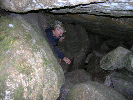
 Now where did Connie go? She was here just a second ago!! | ||
 The Mahoosuc Trail sign. Head the other way and you'll be going toward New Hampshire. | ||

|  |
|
 In one deep crevice there were a pile of moose bones. And looking down between the rocks we could see ice in the middle of August. | ||

|  |
|
 On our left were the steep cliffs of Mahoosuc Mountain. | ||

|  |
|
 An almost flat rock to take our lunch break on. We have a great view of Fulling Mill Mountain as you can see from the picture below. | ||
 Group picture from our lunch rock. Fulling Mill Mountain is the mountain on our right as we head east through the notch. | ||

|  |
|

|  |
|

|  |
|
 Yes, we are still on the trail, I think. It's pretty much just finding a path through the rocks that you think you can navigate. |
||

|  |
|
 We are looking east and I think Mahoosuc Notch is about at the end. Fulling Mill Mountain is at it's end. We turned back here and retreated back through the notch. We wanted to get back to the car before dark. It was a fun and unique hike. Many consider this the toughest mile of the AT, not because you need great climbing skills, but because it's so slow going, especially with those huge packs the thru-hikers carry. |
||
Return to Top | ||