Directions to Notch Trail
Notch Trail trailhead is on Map 17 E5. in the Maine Atlas and Gazetteer Look for a road into Shelter Brook on the map.
Hiking distance: 1.9 miles to the junction of the AT from the parking area on the Shelter Pond rd. Mahoosic Notch is left on the AT and starts within a few yards. The notch is about a mile long. We went through most of it and then retreated and went back down the Notch Trail.
To get to The Notch Trail, which leads to Mahoosuc Notch, we traveled on Rt 2 west towards Bethel. Before getting to Bethel, take a right onto Rt 26 and head towards Grafton Notch State park. I would guess it's approximately 10 miles from Rt 2 to the park. You will pass signs for Screw Auger Falls, Mother Walker Falls and Moose Cave Gorge. About a half a mile or so past the Moose Cave Gorge parking area, there is a large parking area on the left. Continue past this parking area and for 2.8 miles, take a left onto York Pond Road. I believe it's the first left after the big parking area. Shortly this road turns into Success Pond Road. It is 8.5 miles from RT#26 to road to the left. There may be a sign that says Notch Trail spur road or Shelter Pond Rd. Take this road and in there about a half mile the road swings to the right across a couple old bridges and then comes to a large clearing. At the end of this clearing there is a well marked trail to to the left with a Notch Trail sign. Plenty of room to park there.
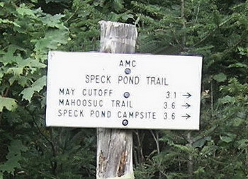
At about 7 miles in on the York Pond/Success Pond Road you will see this trail sign for Speck Pond Trail on the left.

The Notch Trail Spur road is a mile and a half beyond. Some hikers use this as a return route making it about a 9 mile hike.
One other note. When we went, York Pond/Success Pond road was in real good condition. Dusty but a family sedan could easily travel on it. Spring might be a different story but the ice and snow doesn't clear out of the notch until early summer anyway. And those rocks must be treacherous when wet.